Urban Meteo
Urban Meteo
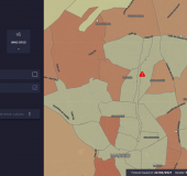
Lifestyles and urban landscapes change from one neighbourhood to another... and so does weather! Events like Urban Heat Islands or localised floods impact the day to day of citizens, and impact city-wide sectors: mobility, municipal services and tourism, among others. To take timely measures that prevent human, economical and societal damage we need tools that allow us to stay ahead of the weather, and provide precise and actionable information. Urban Meteo is a web service that allows you to get high-resolution weather forecast for the urban environment through a simple and intuitive interface. In that way, the user can compare temperature, precipitation, wind and other variables across the same city. Together with its customisable early warning system, this service enables the user to be ready for any meterological event.
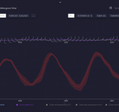
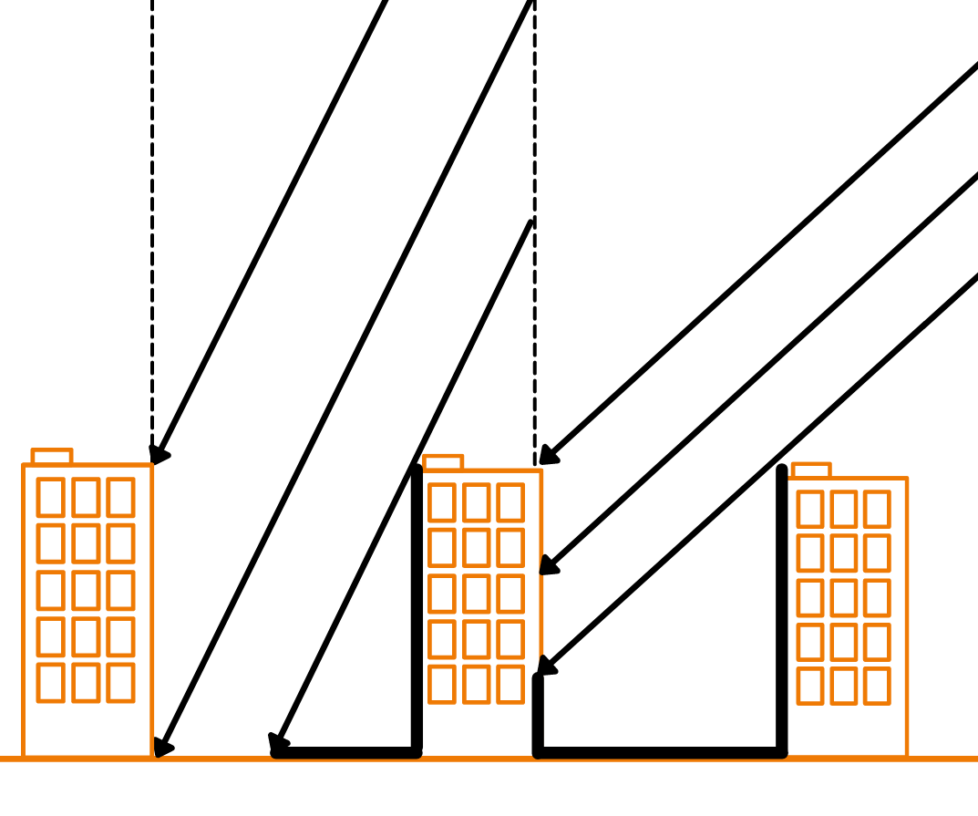
Urban meteorology is not easy. In the urban environment, weather forecasting gets intricate due to several factors—like the variability of land use, the daily cycles in human activity, and other location-specific nuances—that modify the atmospheric behaviour and influence weather. To tackle this challenge, Urban meteo is powered by the WRF model, a cutting-edge atmospheric model that, due to its flexibility and modularity, takes into account parameters of an extremely loacl nature, such as the land use type, traffic levels and building height and the shadow they cast. We add an additional layer of Artificial Intelligence, that allows us to improve the predictions using real-life data from past meteorological observations to adjust the model. This way, Urban Meteo provides extremely precise forecasts, with a high temporal (hourly) and spatial resolution (100m).
These are the main features of Urban Meteo:
- Worldwide coverage: the system can be configured to cover any location in the world.
- Warning system: Urban meteo integrates a customisable warning system, to alert the user when the predicted levels for specfic variables surpasses certain thresholds. This warning system is easily coupled with external communication channels, tailored to user needs (Slack, SMS, e-mail, Whatsapp...)
- Custom data aggregation: emergency responders, urban transport & mobility services, city planners... Each of these sectors classifies and arranges the city in different ways. For this reason, Urban Meteo allows the user to group, aggregate and show the data in different zones of interest (neighbourhoods, elemental health zones...) that can be defined and customised to fit the end-user needs.
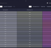
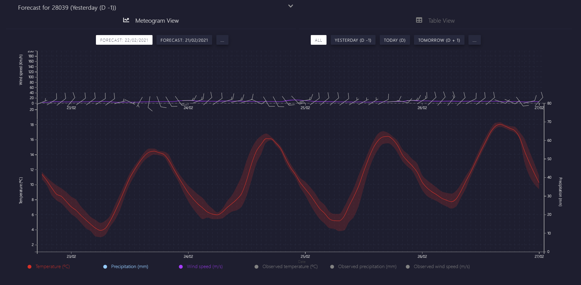
- Up to 4 days of reliable forecasting: we provide daily predictions with hourly resolution that cover the next four days, informing as well of the uncertainty provided by the ensemble of predictions.
For more details, get in touch!
This product has been developed thanks to the "Programa de Ayudas Torres Quevedo - 2016" of the Spanish National Agency for Research, through its Programme for Fostering Talent and Employability, unde the framework of the National Plan for Scientific and Technical Research and Innovation.
Key features
Validated forecasting
Thanks to the WRF model, Urban Meteo reaches its high-resolution predictions for the urban environment. This allows the forecast of highly local events, such as Urban Heat islands and punctual floods. To do this, Urban Meteo makes use of open modules such as WRF-urban. These customisable modules take into account factors such as traffic density, land use, building height and the shadow they cast. This high level of detail is needed to provide precise predictions.
Use-case: Metro Madrid
Since 2016 we work with Metro Madrid ro provide high resolution weather forecast. Among the service we provide, urban Meteo is included, to send daily updates on the predictions, that cover their uderground station network. In addition, we send daily reports through e-mail, as well as timely warnings when the forecast exceed certain operative warning thresholds.
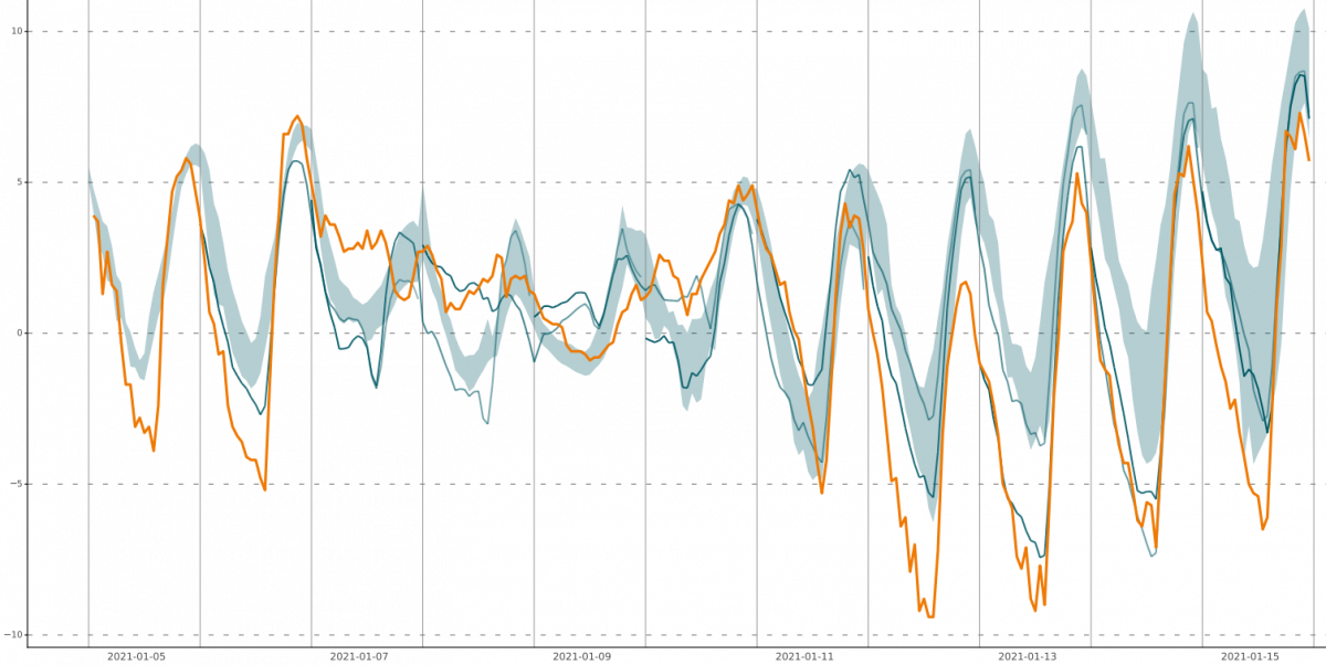
Our close collaboration with Metro Madrid has allowed us to fine tune the service and the post-processing protocol for the WRF model, thanks to the records provided by their dense weather station network. Through statistical techniques, like Kalman filters, we're able to provide forecasts with a low degree of uncertainty, below 1ºC in the case of temperature.These results have been presented on international congresses and conferences (1,2).
Technical specifications
Urban meteo was developed as a Single-Page Application using React framework, the map library Leaflet and the graphical library d3.js. The latest best practices of web development were follower, using a set of libraries that are both secure and widely documented, to miximise future integrations. The service follows a modular designm to ease future developments. The interface is based on diverse web services exposed through a server component based in Java.
The server component allows the strorage, management and access to the data of Urban meteo through an API. This component was developed in Java, using Spring Boot and using PostgreSQL databases to complement the support of geospatial data Postgis.
References
[1] García-Díez M.; Daniel San Martín, Rodrigo Herrero. "Added value of a Kalman-filter in urban-scale forecasts in the city of Madrid". European Meteorological Society Annual Meeting 2018, Budapest (Hungary), September 2018
[2] García-Díez M.; Daniel San Martín, Rodrigo Herrero. "Evaluation of multi-physics urban-scale forecasts in the city of Madrid". European Meteorological Society Annual Meeting 2017, Dublín (Ireland), September 2017