Climate action has taken a central focus in Europe. In December 2019, the European Commission launched the European Green Deal, followed by the European Climate Pact in March 2020—together with the EU Climate Law. The 2030 Climate Target Plan was announced last September. To reach the targets set by these European initiatives, a myriad of actions sprung into action. Across the Research and Innovation landscape, one programme stands out: Horizon Europe. A five-mission approach to tackle the challenges Europe is facing. Four of them are directly related with climate and climate change. But chances are that if you’re reading this you already know about Horizon Europe. So let’s get down to business and explore what we can offer you and your proposal. Keep in mind that this is only a pick of the past roles we haveplayed: we love to tackle new challenges. In addition, we are also open to participate in other programmes—such as LIFE or the European Regional Development Fund—do no hesitate to contact us.
Get in touch if you want to know more!
Tailored, actionable climate projections
Adapting the results from global and regional climate models to be actionable at a local level is not easy. We provide the local climate information that each project needs, by taking care of downscaling, bias adjustment, quality control and climate indexes calculation. Together with the partners and stakeholders of the project, our co-creation workflow enables us to determine, define and develop climate indicators that fit the needs of the different end-users. With this spirit in mind, we’re currently working with FAO, providing actionable projections for agricultural decision-making in MOSAICC. In addition, and thanks to the Copernicus Climate Change Service funding, we’ve recently launched Climadjust: a web service used by over 140 users to obtain custom climate projections.
High resolution weather forecasting & modelling
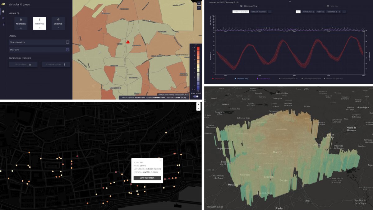
Early warning systems, modelling localised events like urban heat islands, reconstructing past weather events… all these items have one thing in common: they need high-resolution weather modelling or forecasting. Our expertise in handling WRF (an Open Source, highly modular numerical weather model) enables us to perform weather forecasts up to 100m in spatial resolution. To provide trustworthy products, we always perform uncertainty and viability studies, to quantify the skill of the modelling in predicting specific events.
We can couple the weather modelling with early warning systems, to provide a timely heads-up to decision makers. We do this through products and services like Urban Meteo, that provides forecasts for the urban environment. A fully-fledged example of this service is our work with Metro Madrid, where we provide daily forecasts for the whole underground network, paired with an early warning system.
Navigating and handling the European data landscape
Copernicus and its different services, JRC, national meteorological agencies... While these institutions provide an enormous amount of information, navigating the European data landscape can get difficult. 14 years of experience enable us to move comfortably around the multitude of databases offered by European and international initiatives. This puts us in a unique position to obtain not only the data that better fits the problem at hand, but also to homogenise and perform Quality Assurance across different datasets, to ensure solid results.
Climate services development
As software developers, we always keep the user at the center of the process. Through Agile methodologies, we adapt to ever-changing user requirements, keeping a strong focus on uncertainty quantification and communication, as well as standardised validation processes. We think that’s the best way to provide robust, reliable products. Our climate services approach mixes our experience in climate and software development with a close co-creation with the users. In that way we’re able to respond as best as possible to user needs.
User-centered GIS interfaces and websites
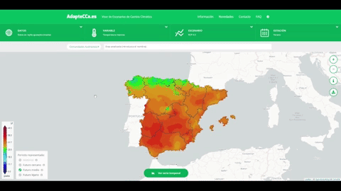
Nearly as important as providing robust and reliable data is showcasing them in a meaningful and useful manner. We take care of front- and back-end, to design and implement swift interfaces. If you want to experience them first hand, visit the Climate Change Scenarios Viewer we developed for the Spanish platform for climate change adaptation, the Data Viewer for the PRIMAVERA H2020 project or our Showcase featuring a myriad of climate use-cases.